![]()
The design of a new roadway bridge under tight site conditions and a compressed schedule might seem challenging enough on its own. Combine that with concurrently implementing new design software and a digital project delivery system, and the mission might seem daunting — more than a consulting firm should tackle at once.
For the firm designing the Lathams Road bridge in suburban Melbourne, Australia, the approach turned out to be a successful combination, as new software tools helped the team deal with various project challenges and also prepare for future projects. Ongoing design revisions and other technical challenges led the team to rely heavily on 3D modeling and other digital tools to complete the project on time.
Shifting Alignments
The AUD 150-million Lathams Road upgrade project includes widening a two-lane road to four lanes over a length of 1.2 kilometers and constructing a new bridge adjacent to an existing bridge, spanning an existing freeway. When Hatch Ltd., the project’s lead designer, discovered the existing bridge location did not match as-built survey information, the team turned to 3D design software to help make design adjustments. As an existing bridge abutment location differed from as-built records by approximately 300 millimeters, the team had to adjust road and bridge alignments accordingly after design was already in progress.
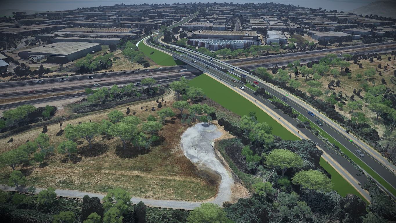
The Lathams Road project widened an existing road from two to four lanes and added a new bridge over an existing freeway. Image source: Hatch. Click image to enlarge.
Using Bentley Systems’ OpenRoads Designer and OpenBridge Modeler to develop designs and 3D models, the team was able to adjust road and bridge geometry and make the necessary adjustments in a week, a fraction of the time required using traditional 2D methods. The ability to seamlessly exchange information between bridge and road models greatly simplified the process, according to team participants.
“If we did not have the 3D modeling approach, this wouldn't have been possible,” said Tanmay Vegad, senior bridge engineer for Hatch. He estimates the changes would have taken four to five weeks using traditional methods. While the team had experience with OpenRoads Designer, the project marked the first time Hatch had used OpenBridge Modeler.
Innovative Bridge Design
The 3D approach also helped the team design modifications to the existing bridge. Due to updated Australian standards, the railings on the existing bridge did not meet current standards for collision resistance, requiring upgrades in conjunction with the new bridge. The team was able to model the railing system and replace the existing railings with a stronger design that met standards without requiring modifications to the existing bridge structure, noted Vegad. The railing design was integrated with the new bridge model, enabling the information to be used to determine quantities and order materials.
For the new bridge, the team faced another challenge: spanning the existing Mornington Peninsula Freeway without interrupting traffic. To do this, the team developed a continuous beam design, which essentially ties two bridge spans together and enables beams to span longer distances. By tying the two spans together with post-tensioned, high-strength steel rods through the ends of each prestressed concrete beam, loads are distributed across both spans, enabling beam depth to be shallower than with simply supported spans, according to Vegad. With a set of five 36.5-meter-long, 1.5-meter-deep prestressed beams spanning each side of the freeway, the precast beams could be placed with minimal disruption to the roadway below.
“The bridge was designed with a specific sequence,” said Vegad. The freeway was only closed briefly to lift the beams into position, he noted. The post-tensioned concrete “stitch” was then placed from above, connecting the two spans, and all other bridge work was conducted from atop the structure.
The bridge design team also developed custom objects in OpenBridge to accurately model bridge components. While OpenBridge includes a library of templates for common bridge components, such as abutments, piers, and barriers, the Lathams Road bridge called for unique shapes not included in the library. Working with Bentley staff, the Hatch team expanded the library with custom objects reflecting the project design, according to Ondrej Krivka, Hatch’s lead modeler on the project.
The project construction contractor also lauded the use of 3D technology on the project. “We believe that the use of 3D software…creates a more efficient design process that has a number of direct benefits to contractors like ourselves,” said Steve White, design manager for contractor Winslow Infrastructure. “3D visualizations promote a greater level of understanding amongst the project team, which has helped to foster a highly collaborative working model between project partners and delivered a fully resolved design. Changes are inevitable, and when they did occur, time and cost impacts were substantially reduced,” he stated.
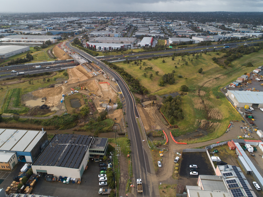
An aerial photo shows the new bridge under construction. Image source: Winslow Infrastructure. Click image to enlarge.
In addition to OpenBridge and OpenRoads, the Hatch team relied heavily on other Bentley tools, including ProjectWise for a connected data environment, ProStructures for structural detailing, OpenBuildings Designer for culvert and wall modeling, LumenRT for visualization, ContextCapture for reality mesh development, MicroStation for plan production, and iTwin for digital twin and design review. The client, Major Roads Project Victoria (MRPV), required deliverables in MicroStation DGN format.
For structural design and analysis, the Hatch team used SpaceGASS by Space Gass Pty Ltd and Strand7 by Strand7 Pty Ltd, tools the team’s designers had used extensively on Australian projects. In the future, Hatch may explore using structural design and analysis modules included in OpenBridge. For the Lathams Road project, the challenge of learning yet another set of tools was, “Pardon the pun — a bridge too far,” said Michael Gilham, Hatch’s global solution lead for civil work.
Civil Challenges
Beyond the bridge, roadway designers faced other challenges, such as tight right-of-way limits and a shared-use path located adjacent to the roadway. The team often had to tweak designs to fit all the project elements into tight spaces, according to Liam Wilks, Hatch’s global application development lead for OpenRoads/OpenRail.
“There was a lot of change throughout the project, even right up to each milestone deadline,” said Wilks. When design changes occurred, data compatibility between various software products was key to exchanging information among designers. The ruled geometry feature of OpenRoads was particularly helpful in propagating changes across the model, noted Wilks. “When we changed something at the perimeter, a lot of [the design] would automatically update,” he said.
In certain locations, the team also prepared special visualizations. For example, with portions of the path subject to flooding, the team combined modeling data with photographic images to develop reality-mesh visualizations. “We were able to extract the raw drone images provided by the client and run that through ContextCapture, and that resulted in a very good reality mesh,” said Wilks. The modeling data and visualizations were useful in identifying and displaying flood information and other water-resource issues, he noted.
Digital Project Delivery
Along with the numerous project challenges, the team was learning OpenBridge Modeler and had to ramp up quickly, obtaining training from Bentley and integrating OpenBridge with the company’s digital project delivery (DPD) initiative. The company is implementing DPD to increase information value and drive quality and efficiency, extending the life of information into operations, according to Gilham. The firm is committed to following ISO 19650, an international standard for building information modelling (BIM), on every project.
From Bentley’s perspective, Hatch’s approach was a good fit for the project and the company’s workflows. “Bentley has been positioning and advocating this type of approach and solution set for a couple of years now,” said Dave Body, senior industry strategy manager at Bentley. “Hatch undertook detailed training coupled with on-going project-based ‘over the shoulder/on the job coaching.’ Additionally, there were regular (and ad-hoc) scheduled meetings performed between the Hatch project team and Bentley OpenBridge Modeler subject matter experts to ensure steady progress was achieved throughout the project’s lifecycle,” noted Body.
Hatch’s two-pronged approach to meet company objectives and a tight project schedule presented a unique combination of challenges, but one that appears to be well worth the effort, said Gilham. “It was baptism by fire,” he noted. “The project helped us move the DPD project forward at the same time. The team did an amazing job to get the project out on time and on budget.” Final deliverables were actually delivered four weeks ahead of schedule, he added.
Augmented Reality
As construction has progressed toward a 2023 completion, digital modeling information has continued to provide value on the Lathams Road project. Hatch’s 3D model was exported to Trimble’s SiteVision augmented reality (AR) system to display the design in the field. The use of AR has aided constructability and helped avoid conflicts with existing infrastructure, according to Gilham.
Contractor Winslow also recognized benefits from AR. “Winslow Infrastructure was able to directly import 3D model information into site visualization platforms and plant-based exclusion/lock out software, which has benefited our engineers on the ground and machinery operators,” said White.
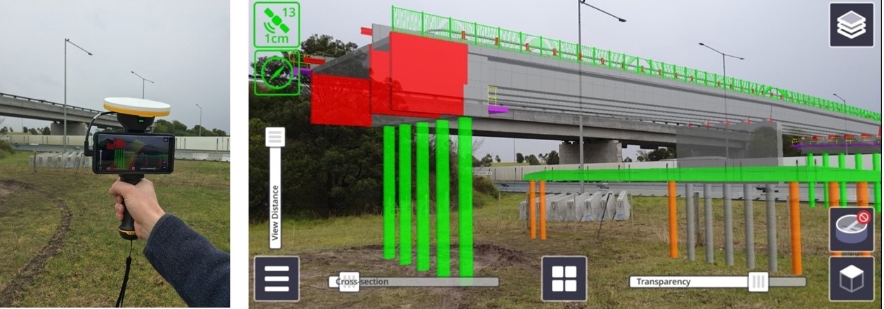
Augmented reality was used to display the 3D model in the field. Image source: Hatch. Click image to enlarge.
Future Projects
With the Lathams Road project under its belt, Hatch is actively applying its expanded 3D experience on other projects. The company recently completed the design of the Hall Road upgrade, another project for MRPV. On that project, Hatch used a similar suite of software to model the project, which featured 24 culverts of various sizes and shapes. “Using this same workflow, we achieved a very high efficiency in producing the design and keeping up with changes,” noted Vegad. The Hatch team anticipates applying the knowledge on future projects as well, both for MRPV and other clients.
From the technology standpoint, Bentley’s Body identified lessons learned for future projects where a new workflow and solution set is adopted. “Prior to project kick-off it is best to jointly define the scope, goals, required deliverables, and desired outcomes of the project with project participants in an effort to recommend a best-practice approach,” he said. Detailed training and follow up is also key to provide additional support and ongoing confidence to the project participants, he noted. Since completion of the Lathams Road design, Bentley has also added some capabilities to OpenBridge Modeler, such as additional support for modeling structural shapes.
The use of 3D modeling and digital project delivery established dramatic benefits for designers and other stakeholders on the Lathams Road upgrade, a key infrastructure improvement in the Melbourne suburb of Carrum Downs. As technological experience grows in the AEC industry, similar approaches are likely to be adopted by other firms and agencies worldwide.


Share This Post