![]()
For anyone who worked on a survey crew a decade or more ago, a common scenario was the laborious collection of field data required to create design, construction, and as-built drawings. In general, key point locations were obtained in the field, then transferred to an office environment to create site maps, drawings, and other documents. Technological advances such as laser scanning helped expedite the process and enable rapid collection of massive amounts of data, but the data still generally required additional processing to be used in CAD, BIM, or GIS environments.
More recent advances are enabling data collection, visualization, and analysis to be conducted seamlessly in real-time on mobile devices, potentially saving significant time and costs for owners, designers, surveyors, planners, and builders. The concept of augmented reality (AR) —combining real-world and computer-generated content into a unified experience — is moving beyond entertainment and design settings into boots-on-the-ground construction applications.
AR technology is finding new uses in products such as Trimble’s SiteVision software, which recently added LiDAR (light detection and ranging) scanning capabilities to its feature set. Introduced in 2019, SiteVision enables users to visualize and explore spatial data on a mobile device in various stages of the construction lifecycle. The addition of LiDAR scanning in SiteVision 5 has opened new doors for field tasks such as viewing point cloud capture in real time, determining material volumes, and visualizing existing and proposed facilities in one view.
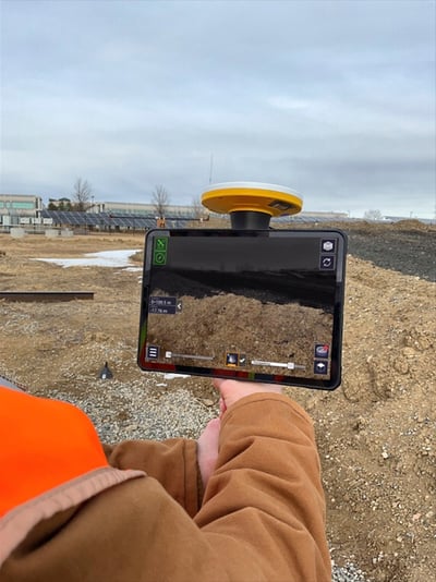
SiteVision enables users to visualize and explore spatial data on mobile devices. Image source: Trimble.
AR Makes Its Mark
SiteVision’s AR capabilities are “leaps and bounds from where it was originally when it first came out,” said Mike Tartaglia, technology specialist at SITECH Southwest, a Mesa, AZ-based provider of construction technology solutions. With the additional LiDAR scanning features, he sees particular value for construction contractors in tracking material volumes, where field personnel can scan a stockpile of dirt and send georeferenced data back to the office with the press of a button. This enables contractors to closely monitor material volumes in real time. “There is no more second guessing. The contractor can now have almost instantaneous data [as a project progresses],” he said.
In another example, Tartaglia noted how SiteVision was used to remotely visualize a yet-to-be constructed house on an inaccessible site. With muddy conditions preventing the homeowners from accessing the site via automobile, Tartaglia worked with the contractor to connect a cell phone and tablet via mobile WiFi and project a visualization of the house layout overlaying actual site conditions. After aligning a PDF drawing of the building footprint with other design data in SiteVision, the contractor was able to walk the site with a cell phone and project the composite view onto a tablet the homeowners were viewing in their car.
“The contractor was able to show them where he was walking on the PDF and say, ‘Here's where your bedroom is, and this is going to be your view out of this window.’ He was able to make things come alive to a client that wouldn't otherwise be able to visualize something,” said Tartaglia.
Bringing Users Together
Trimble considers SiteVision a “cross-departmental product,” according to Bryer Palmer, Trimble product manager. “It is designed with the GIS surveyor, the construction surveyor, and the building contractor in mind,” he noted.
In a typical construction configuration for SiteVision, a LiDAR-equipped mobile device is connected to a GNSS (global navigation satellite system) receiver such as Trimble’s DA2 smart antenna and mounted on a range pole to collect data. The data can be georeferenced to achieve centimeter accuracy. For more precise accuracy, users can use stationary scanners, according to Palmer. SiteVision is “designed to take care of the same applications of a stationary scanner, but perhaps ones that require less accuracy, and require more simplicity, speed, ease of use, and still very good accuracy,” he said.
The stockpile example is particularly well suited to SiteVision because of the real-time capabilities of the tool, noted Palmer. As construction progresses, SiteVision enables field personnel to walk around a stockpile and calculate dynamically how much material is being moved in just a few minutes. In contrast, setting up a stationary scanner in multiple places to get similar data would take much longer, and using drone scanning would require multiple drone flights.
For small-scale scans, users can use a LiDAR-equipped mobile device without a GNSS receiver, but accuracy and range may be limited, according to Palmer. SiteVision can use the phone's LiDAR sensor, AR tracking cameras, and accelerometer to obtain data, but only within approximately a 5-meter radius, he said.
Looking Underground
Utility location provides another prime opportunity for mobile LiDAR scanning, noted Palmer. With a setup similar to the stockpile measurement, users can create a full visualization of an underground utility as it is being installed, versus manually surveying a series of points on top of the utility line to generate an as-built drawing. Users can also see the trench limits and monitor material volumes as the trench is filled in. “You can even adjust your design to match the actual conditions of the as-built,” added Palmer.
Mobile scans can be created to visualize underground utility construction as it progresses. Image source: Trimble. Click image to enlarge.
Users can also visualize multiple utilities in the field, noted Tartaglia. Using SiteVision in conjunction with the underground utility module of Trimble’s Business Center, owners, designers, and contractors can generate 3D visualizations of existing and proposed utilities, essentially creating a digital twin of underground utilities. “You can go out there, look underground, see the 3D objects, and say, ‘This is the area where we have a water valve or some form of pipe’,” he explained.
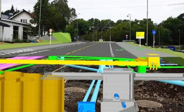
Underground utilities can be visualized in the field. Image source: Trimble.
After construction, SiteVision data can be used in conjunction with GIS data, enabling owners to record as-built conditions for access later. “You have a live, expandable ecosystem,” said Tartaglia, citing an example of using SiteVision data to develop 3D networks of underground utilities for operations and maintenance purposes.
Visualizations can also include property boundaries and other GIS information, added Palmer. Surveyors can import and visualize property information to help locate buried monumentation such as property corner pins. “Basically, any type of file that has design information, you can put in SiteVision, and see the boundaries of your property. And with this combined information, you can see the initial conditions versus the proposed design of what needs to go there.”
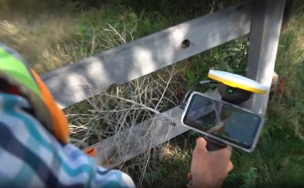
Surveyors can use SiteVision to visualize property information and locate monumentation. Image source: Trimble.
In the future, Trimble may incorporate more tools to manage data in the field. “Our customers are interested in being able to adjust data in real time. They would also like the ability to perform a full workflow as conveniently as the contractor needs it,” said Palmer.


Share This Post