![]()
With the growth of data collection technology in the last decade, civil engineers and surveyors have been grappling with an escalating challenge — too much data at the front end of projects. Light detection and ranging (LIDAR) and other technologies have enabled project teams to obtain highly detailed ground modeling data, but the massive point cloud datasets — sometimes containing millions of points — have also choked computer systems unaccustomed to dealing with so much data.
To handle the data onslaught, AEC professionals have used various approaches — subdividing models into smaller pieces, using data-thinning features in CAD or data collection software, or in some cases developing proprietary solutions. While each approach has its pros and cons, solutions offered in BricsCAD are capturing the attention of some industry professionals. Launched in 2004 by then-startup Bricsys, which is now part of Hexagon, BricsCAD has added some unique features specifically geared to handling large datasets. The product also has a flexible licensing model that is appealing to firms with employees who only use CAD on an intermittent basis.
Simplifying Complex Models
BricsCAD’s Civil Explorer includes several different ways to simplify complex ground models. Users can interactively simplify different portions of a triangulated irregular network (TIN) model with different levels of detail. For example, a flat, undeveloped area can be modeled with a lower point density than an existing road or an area in which new facilities are being designed. “You can easily create a variable-density TIN surface,” said Don Strimbu, BricsCAD head of product. “You can add density in areas of interest and simplify the TIN in other areas to reduce calculation time throughout the life of the project.”

BricsCAD allows users to interactively simplify large TIN surfaces. Image source: Bricsys. Click image to enlarge.
The interactive nature of BricsCAD’s tools allows users to experiment with different point densities in different parts of the model until they are satisfied with the results. Instead of having to undo or redo the entire modeling process, users can select different thresholds of simplification for different geographic areas. For example, data points within a certain horizontal and vertical tolerance of each other can be eliminated in one area, and a different tolerance can be used elsewhere in the model. It’s a different approach than rudimentary data-thinning algorithms, which essentially eliminate points based on a uniform, grid-based spacing.
“We have gone beyond grid-based decimation,” noted Rick Ellis, BricsCAD civil platform product owner. “We’ve added user-defined parameters, where you can skip over points within a certain tolerance. Then you can go back and re-densify based on project needs.”
CAD and Survey Tools Intersect
For BricsCAD user Land Surveys, an Australian surveying and geospatial company, BricsCAD has been used on both the front end and back end of projects. The company often receives data from clients in CAD format and is required to, “clean up the data to enable a more usable format,” said Leon Sneddon, national technical coordinator for Land Surveys. They have used BricsCAD for tasks such as eliminating hatch patterns or enabling translational adjustments to make data spatially correct before importing it into other survey software.
On the back end, Land Surveys often uses BricsCAD for basic drafting and modeling functions. “It can be useful for handling 3D phases — being able to manipulate and merge information,” Sneddon noted. Although the company developed its own software — IntelliSpatial Portal — for managing large point cloud data sets and providing a visualization and data management platform, it has found BricsCAD’s tools effective for simplifying TIN triangles and merging data to create unified digital terrain models (DTMs).
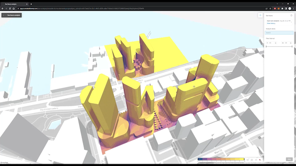
On a recent survey of an arterial road in Australia, Land Surveys needed to deliver a 3D model for a detailed flood study. After acquiring data from a combination of mobile laser scanning (MLS) and terrestrial laser scanning (TLS) methods, the company used BricsCAD to modify and join multiple DTM surfaces for the final deliverable. “It’s really easy and efficient to work with,” added Sneddon, noting that BricsCAD is one of several CAD-related products used by the company. With a variety of projects and clients, the company also uses LISCAD, Leica Geosystems, and Microsurvey by Hexagon; 12d Model by 12d Solutions; and various Autodesk and Bentley products.

BricsCAD was used to help develop a 3D model for a flood study in Australia. Image source: Land Surveys. Click image to enlarge.
Another attractive aspect of BricsCAD is a flexible licensing program. Because Bricsys offers both individual and network licenses, companies like Land Surveys can use a network version to pool licenses so intermittent users can access the product on an as-needed basis. “We have 200 surveyors who might need access, but some of them might only use it two hours per day,” said Sneddon. “With the pooling of licenses, you can be anywhere and have access. It reduces our overall cost of licenses,” he said.
The license flexibility and ground modeling features are also attractive to Oregon-based AKS Engineering & Forestry, LLC, according to Chuck Litchfield, AKS CAD Manager. The firm has been evaluating BricsCAD and may be introducing it firm-wide in the near future. With multi-user licenses “we can give people who don’t often use CAD the opportunity to open and edit drawings,” said Litchfield.
Because AKS collects data with a variety of methods, including aerial, ground-based, and underwater surveys, effective point cloud processing is key, said Litchfield. The firm tested BricsCAD on a project modeled with other software and found they could “achieve the same result in fewer steps” with BricsCAD, according to Litchfield. “It is refreshing to see the creative improvements being made to this software,” he noted.
The ability to customize BricsCAD with LISP programming also has benefits for AKS and other firms who occasionally need to develop custom routines for firm-specific use. In addition to LISP, BricsCAD can be customized with other programming environments, such as .NET, VBA, BRX (a BricsCAD-specific API similar to Autodesk’s ARX), and TX (a C++ API provided by the Open Design Alliance). BricsCAD opens and saves DWG files directly with no conversion necessary.
Hexagon Connections
With Bricsys’ acquisition by Hexagon in 2018, BricsCAD gained access to new resources and connections to a variety of AEC-related solutions under the Hexagon umbrella. With Leica Geosystems also a part of Hexagon, along with a host of construction execution and progress documentation tools, engineers and surveyors might find collaborative opportunities with multiple products “under one roof” according to Ellis. As a former CAD manager in the AEC industry, he recognizes the importance of vendor stability in the eyes of AEC firms. “This is not a small company that’s going to evaporate,” he said.
Evaporation of point data is another matter — in fact a high priority goal for firms and agencies dealing with large datasets. With its unique approach to making DTMs more manageable, BricsCAD could find itself in the toolboxes of users who hadn’t heard of the product until recently.
BricsCAD is currently available in several editions: Lite, Pro, BIM, Mechanical, and Ultimate. The Civil Explorer features are available in the Pro and Ultimate editions.


Share This Post