Historically, geographic information systems (GIS) and building information modeling (BIM) technology have lived in separate worlds. Each field has relied on unique tools, data, and expertise, with GIS primarily used for mapping and planning purposes and BIM used more for design, construction, and manufacturing. Data exchange between the two environments often required arduous import/export and manipulation efforts.

Image source: Saulo Studio/stock.adobe.com.
As technology has matured, barriers separating GIS and BIM have been greatly minimized, making integration more feasible. As computer-aided design (CAD), which initially served primarily as a drawing and plan-production tool, morphed into BIM, data has been more widely used across project lifecycles and maintained in information repositories somewhat similar to GIS data. Improved hardware capabilities have made large datasets more accessible to a wide range of professionals.
Key industry partnerships have also greatly improved interoperability. An alliance between Autodesk and Esri in 2017 formalized efforts to integrate the two technologies, enabling GIS and BIM professionals to more easily share data and realize a host of benefits.
“As the leaders of the respective industries worked together, it opened up many doors,” said Ron Couillard, Technology Consultant at ARKANCE, which provides technology consulting services to public and private organizations. “Historically the fields have been siloed, but that does not need to be the case anymore.”
 |
“As the leaders of the respective industries worked together, it opened up many doors,” said Ron Couillard, Technology Consultant at ARKANCE. “Historically the fields have been siloed, but that does not need to be the case anymore.” |
Benefits of Integrating BIM and GIS
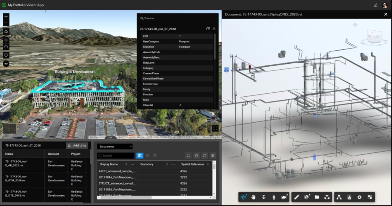
The Autodesk-Esri alliance resulted in key product refinements and new products. Esri’s ArcGIS GeoBIM interconnects Esri’s flagship ArcGIS technology with Autodesk Construction Cloud products, enabling teams to integrate and visualize project data in a single platform and aid tasks such as design coordination, issue tracking, and performance management.
On the Autodesk side, the Autodesk Connector for ArcGIS enables two-way, synchronous collaboration between BIM and GIS platforms. With this capability, Autodesk Civil 3D, InfraWorks, and Map 3D users can bring GIS content directly into a design model, supplementing models with maps, layers, imagery and other GIS data. Autodesk users with appropriate permissions can also edit and update GIS data from the Autodesk environment.
The ability to exchange data between GIS and BIM environments translates into huge time savings and numerous other benefits for AEC professionals. Rather than spending time preparing and manipulating data, users can import data seamlessly and work with it in either GIS or BIM environments.
The Autodesk Connector, for example, can automatically translate imported GIS data into intelligent Civil 3D objects, such as alignments and parcels, or it can import the data as AutoCAD entities such as polylines. The connector can also stylize data and apply user-defined CAD standards. For agencies with consistent layering guidelines, users can develop templates to define which GIS information gets translated into corresponding Civil 3D objects. These templates can also be used to stylize the incoming GIS data by giving the option to select Civil 3D styles and layers.
Esri’s ArcGIS GeoBIM interconnects ArcGIS with Autodesk Construction Cloud products. Image source: Autodesk.
The ability to access live GIS data in real time also offers significant benefits, providing access to current data throughout project lifecycles. This smooths coordination and data sharing between different organizational departments, such as planning and design. Smoother data exchange also improves the ability to reuse data, rather than recreate or reacquire data that might already be available.
For GIS professionals accessing BIM data, GeoBIM enables users to bring in data from Civil 3D, Revit, and other models and aggregate all the data in the same GIS environment. This enables users to easily view data from various perspectives and identify potential clashes and other key information that might not have been discernible in other formats.
The improved data-sharing capabilities also offers benefits beyond planning and design. During construction, the ability to access integrated BIM and GIS data can help construction teams plan activities and monitor project progress. With the ability to view projects in the context of their surroundings, construction teams are better equipped to make key decisions related to staging, material delivery, and other geospatial-related considerations.
After construction, the integrated data can aid owners with maintenance and operations activities. Accessing current infrastructure information, government agencies and private facility owners can better plan for equipment maintenance and replacement, as well as future improvements and expansions. In emergency situations such as fires and floods, the information can provide real-time guidance for emergency management, rescue, repair, and other key efforts.
For government agencies, BIM-GIS integration can help personnel better communicate across departments. Planning, surveying, engineering, and other professionals can access the same data in real time with simpler logistics and less confusion than in previous arrangements.
For AEC firms, BIM-GIS integration opens doors to expanded capabilities and new markets. Prospective clients typically value one-stop shopping, where one firm can provide multiple capabilities, such as both BIM- and GIS-related services. And additional efficiency gained through integration can improve productivity and profitability, while also helping address labor shortages prevalent in the AEC industry.
Global AEC firm HDR, has seen BIM-GIS integration benefit both clients and project teams. “The beauty of what we’re able to do now is integrate that information dynamically. Now our clients and our teams can access information in a way that they previously couldn’t,” said Cameron Schaefer, Transportation Data Acquisition & Reality Mesh Director at HDR.
Schaefer said the integration also saves significant time on projects. “If something that used to take two weeks can now be done in a day, that’s time savings,” he noted.
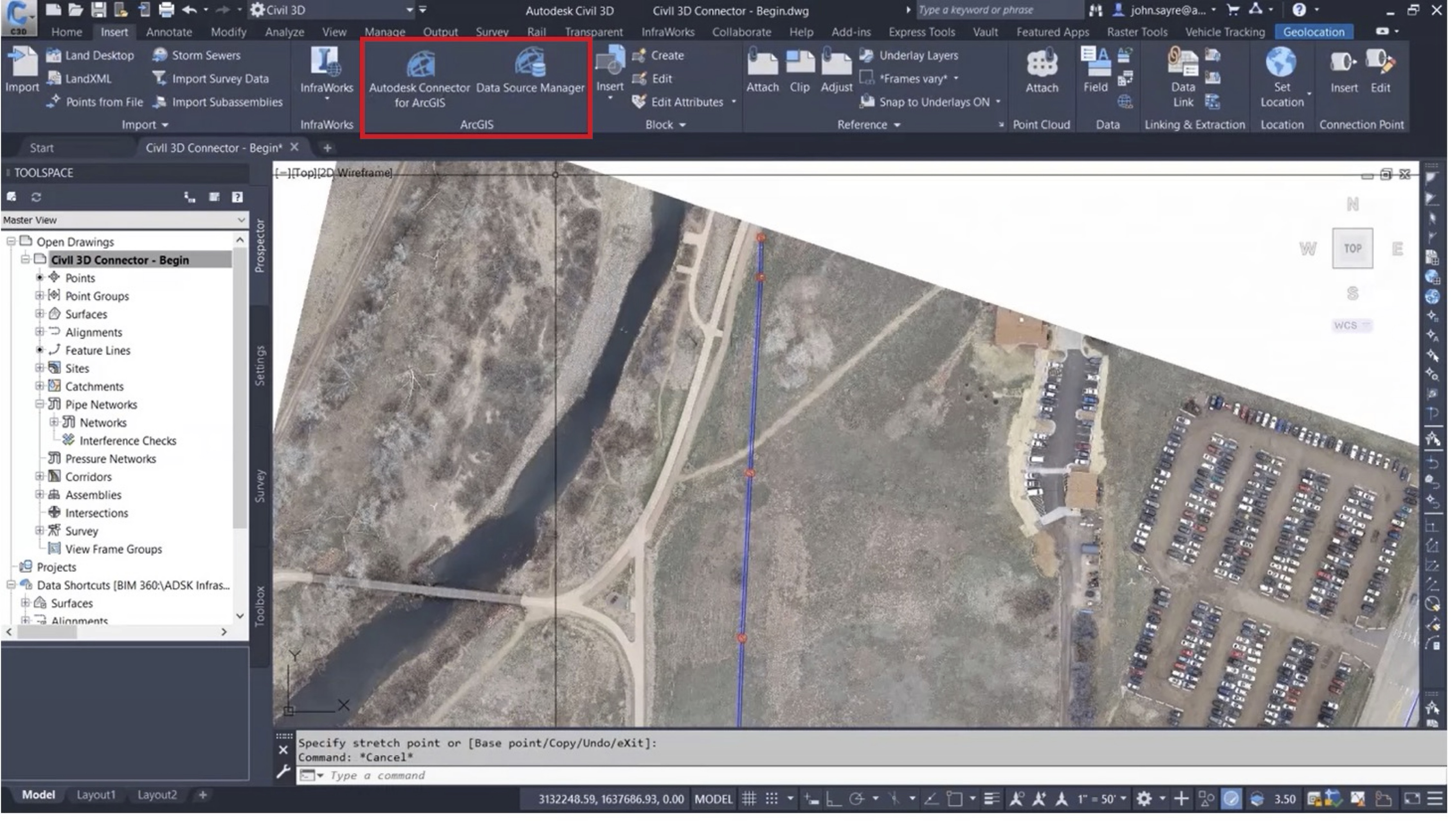
Autodesk Connector for ArcGIS enables direct exchange of GIS data with Autodesk Civil 3D, InfraWorks, and Map3D. Image source: Autodesk.
Integration Challenges
While BIM-GIS integration offers numerous benefits, it is not without challenges. Some organizations may need to upgrade hardware to handle larger datasets. In general, a workstation equipped for Civil 3D can handle the demands of GIS data, but in some cases additional memory or computing horsepower may be needed. To minimize screen refresh time and other potential delays, workstations should have more than the specified minimum requirements for Civil 3D, according to Couillard.
Training may also be required to acquaint users with new tools. The Autodesk Connector is self-explanatory, so an experienced Civil 3D user can usually get up to speed with an hour or two of training, said Couillard. The GeoBIM tool might require a few hours of training, but still a manageable learning curve.
Education on different data sources and formats might also be required. GIS and BIM professionals may need to better understand unfamiliar data formats. Data precision can also vary, and professionals need to understand the precision of data emanating from multiple sources. With thorough knowledge of various data sources, potential for successful integration improves. “Many people don’t realize both technologies can consume each other’s data,” said Couillard.
Some users may be apprehensive about integrating because it could alter responsibilities and roles. With proper management support and openness to change among staff members, these adjustments can be navigated with minimal disruption. “Some managers of GIS and engineering professionals have been told, ‘There’s no way for us to talk to each other,’” observed Couillard. In reality, that assumption is no longer valid, and integration can help improve collaboration, benefiting multiple departments, he noted.

Image source: adnananwargfx/stockadobe.com.
Implementation Integration
To get started with BIM-GIS integration, wise organizations work with a partner. A technology consultant such as ARKANCE, can offer a variety of training and mentoring options to help integration processes. With consultants highly experienced in the AEC industry, ARKANCE can help organizations assess their resources and workflows to identify adjustments needed to better integrate BIM and GIS.
An experienced technology consultant can help organizations focus training efforts on applicable projects, rather than hypothetical training exercises. With a combination of fundamental training and project mentoring, ARKANCE can develop training based on actual projects so attendees can be productive and billable during much of the training period.
In many cases, ARKANCE has worked with clients on pilot projects for Civil 3D and other implementations to make best use of training efforts. With thorough planning and preparation, training attendees can be productive with the software in early stages of training.
Couillard also advises starting with smaller projects when learning new concepts such as BIM-GIS integration. For example, a firm designing residential subdivisions should start with a 50-lot subdivision rather than a 500-lot subdivision when implementing integration.
ARKANCE can also guide clients on tailoring training delivery to meet specific needs. In some cases, in-person training may be the preferred option based on a company’s current projects. In other cases, remote or virtual training is more effective. For some organizations, a combination of training methods is effective.
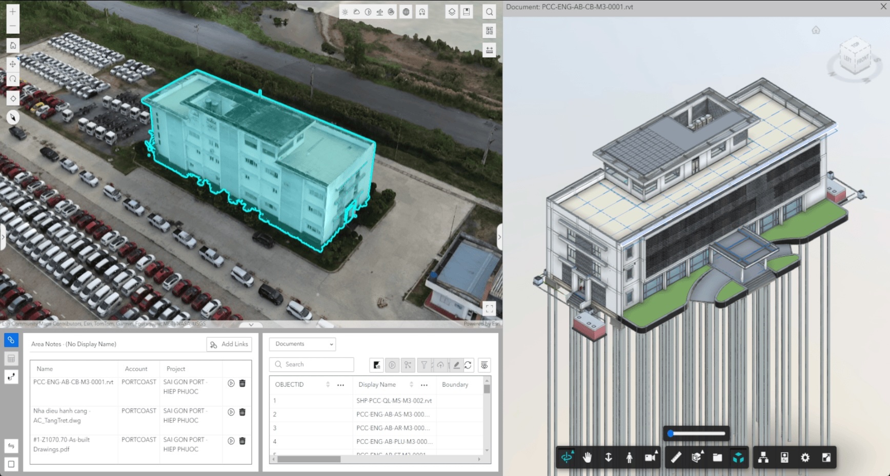
ArcGIS GeoBIM connects geospatial data with design and construction information to see your projects and assets in context. Image source: ESRI.
What’s Ahead?
As BIM-GIS integration becomes more prevalent, other technology trends may also shape future workflows. Artificial intelligence (AI), which is impacting all facets of daily life, continues to make inroads in AEC and GIS workplaces. Autodesk in 2023 launched Autodesk AI, which introduced conversational features to access AI-generated AutoCAD-related support, as well as predictive analysis features and other AI-driven tools in Autodesk Construction Cloud products.
Esri’s ArcGIS includes embedded AI-powered GIS tools and pre-trained models that aid workflows such as object detection in imagery. Coupled with rich datasets and high-resolution imagery, ArcGIS AI assistants and conversational interfaces can walk users through analytical processes and democratize spatial analysis across organizations.
Virtual Reality (VR), augmented reality (AR), and extended reality (XR) also continue to find new applications. While still in relative infancy in AEC and GIS circles, VR/AR/XR can leverage BIM and GIS data into interactive, immersive experiences that help teams improve communication and make better-informed decisions.
Other technology advancements such as automation, IoT sensors, and drone technology are likely to put additional power in the hands of BIM and GIS professionals. By working with an experienced technology consultant, organizations can be better prepared to apply new technologies as traditional barriers between disciplines fade and new opportunities arise.
***
This article was sponsored by ARKANCE.
Download this article as an eBook today!


Searching for more information about Architecture, Infrastructure, and Construction?
Click here!