
With Southern California experiencing dramatic, ongoing population growth, a regional planning organization is ramping up efforts to share GIS data and resources to help manage this growth in a sustainable manner. The Southern California Association of Governments (SCAG), in partnership with GIS software and mapping technology provider Esri, is introducing a revolutionary system to encourage more collaboration and bolster planning capabilities both locally and regionally.
The Regional Data Platform (RDP) aims to address deficiencies in planning resources by equipping local agencies with additional technology, data, and best practices. Along the way, SCAG is seeking to streamline the process of collecting and integrating data from member agencies into regional systems and enhance regional planning.
Identifying a Need
Encompassing six counties and 191 cities in an area covering more than 38,000 square miles, SCAG is an association of local governments and agencies that monitor and address regional issues such as housing, environmental resources, and infrastructure planning. In a 2018 region-wide survey, SCAG found that 70% of local agencies lacked technical staff to analyze data and 43% had no in-house GIS support.
The survey numbers confirmed what SCAG had sensed for years — that many local jurisdictions within its boundaries lacked resources to keep planning data up to date. As the metropolitan planning organization for 19-million people — the largest in the U.S. — SCAG saw an opportunity to help level the playing field.
“We really changed our focus to not just doing long-range regional planning, but providing resources and tools for our local jurisdictions to build on,” said Darin Chidsey, SCAG’s chief operating officer. “We wanted to take some of the ideas and policies that were in our long-range plan to the communities.”
After numerous internal discussions, SCAG developed a vision for the RDP and embarked on a procurement process that engaged Esri as a partner in 2018. The system is being rolled out in phases, with testing initiated in 2021 and full implementation planned for mid-2022.
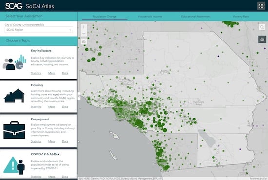
The Southern California Association of Governments encompasses six counties and 191 cities. Image source: Esri.
Key Components
The RDP includes three key components: data and information tools, planning and engagement tools, and data sharing tools and workflows. The data and information tools include a regional collaboration hub for accessing data and the SoCal Atlas, a web-based application that allows users to explore maps and statistics across various topics and geographies.
As part of the planning and engagement tools, SCAG is providing each member agency with a suite of Esri licenses available for assignment to one designated staff member per jurisdiction. The suite includes ArcGIS Online, ArcGIS Pro, ArcGIS Urban, and Business Analyst Web. The planning and engagement tools also include custom applications such as HELPR, which provides the ability to evaluate real estate parcels for residential development.
Data sharing tools include a local data exchange website, a data editor, and other tools for sharing local data with SCAG in an effort to inform regional plans and policy. A data reviewer provides a workflow for member agencies to review and approve edits to data within their jurisdiction.
As the first component to get rolled out, the HELPR tool is already being used in assessing regional housing needs, one of the more pressing issues in Southern California. HELPR assists jurisdictional planners in meeting a state-mandated requirement to identify parcels suitable for residential development or redevelopment in their community.
“We are in the midst of a housing crisis,” said Chidsey. “We as a region need to think about how many housing units we need to build over the next 10 years. And then we disaggregate that information down to each city and county that we represent. The HELPR tool is designed to help cities start that process.”
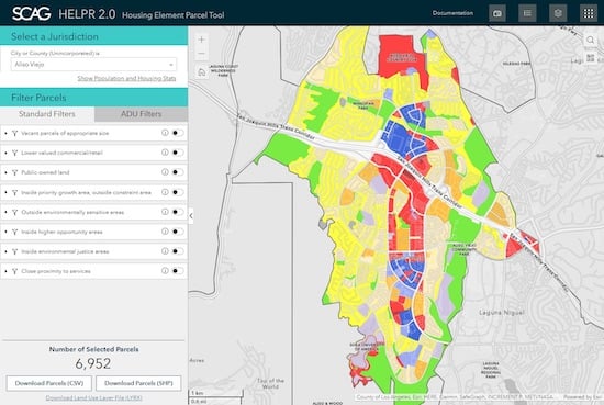
The HELPR tool provides the ability to evaluate real estate parcels for residential development. Image source: Esri.
Lofty Goals
Beyond the HELPR tool, additional tools are being developed to help stakeholders discover information about specific parcels and to help agencies communicate information about their general plans. The custom tools, along with the off-the-shelf Esri products, are intended to better equip local agencies in helping SCAG address issues that span multiple jurisdictions across the region.
“SCAG ‘s Regional Data Platform is pioneering a new model for government-to-government collaboration,” said Caitlin Smith, Esri’s RDP project manager. “We can't solve problems that are systemic in nature if we're working in silos. Data sharing and collaboration have been these lofty ideals we've been moving toward, but we haven't had the technology in place. We finally developed this technology [to meet that challenge].”
SCAG also foresees more than just planning agencies benefiting from RDP. “We envisioned a tool that could be used not just by local governments, but by researchers worldwide and the general public,” said SCAG’s Chidsey. “The tools have been developed with multiple end users in mind, providing a baseline for public input. [The RDP] has a user interface that allows the user to create what they want to see. You get to select what layers you want to see and the area where you want to focus. That user experience becomes very unique.”
In addition to providing specific tools to member agencies, SCAG is also providing training for those agencies. “We are able to add some scale to bring the region’s planners up to speed and provide them value,” added Chidsey. “The training component is very critical.”
Shaping Infrastructure Plans
Once rolled out, the RDP is also expected to play a key role in infrastructure planning. Chidsey sees the RDP helping shape Connect SoCal, the region’s long-range visioning plan that balances future mobility and housing needs with economic, environmental, and public health goals.
“The information that we're sharing and gathering through this process really becomes the heart and soul of that plan,” he said. “The more we understand, the better we can plan.”
Connect SoCal includes more than 4,000 transportation projects — including highway improvements, railroad grade separations, bicycle lanes, new transit hubs, and replacement bridges. The plan looks out 20-plus years to assess transportation and housing investments throughout the region, and is updated periodically.
“It's a process we go through every four years that really starts with updating our forecasting data,” said Chidsey. “We’re thinking about how many people are going to live in Southern California — how many households, and where housing might be. Where are the jobs going to be? How do we do the best job of ensuring that the transportation systems are going to be built to support that? And we do all this with an eye toward environmental benefits such as improving air quality.”
Based on knowledge gained through the RDP project, Esri’s Smith sees potential for similar efforts across the U.S. “We feel like this pattern has so much potential elsewhere, with the caveat that a lot of what makes this work relies on people, and people are different everywhere. We feel the technology is strong, but community building and adoption of that technology are key to driving change and transformation. It has been no small task. SCAG has done a wonderful job of engaging the member agencies region to make this initiative a success.”
The collaborative approach of the RDP could indeed gain interest beyond Southern California, as many of the issues facing that region are also prevalent in other parts of the U.S. and across the globe. SCAG’s emerging model for government-to-government collaboration could play a key role in addressing these issues.
If you have GIS-based ideas or projects you think are newsworthy, drop us a line at editors@cadalyst.com.


Share This Post