
The ever-expanding availability of geospatial data and constantly evolving technology have brought new dimensions to GIS workflows in recent years. Increasingly, GIS professionals, urban planners, and others are employing 3D data and technology as they build maps and other planning products, previously considered primarily 2D products.
In Oslo, Norway, the use of 3D GIS has enabled city planners and others to better envision projects and communicate data to a wide variety of audiences. 3D tools and data are also increasing collaboration between GIS professionals and engineers, architects, and others, leading to an expanding list of applications for GIS.
As an example, the city of Oslo was looking for ways to identify suitable locations for Ukrainian refugees to live in the city. Combining various data sources with 3D models of the city, GIS teams could display information such as healthcare facilities, trees, noise, and solar radiation in views that were easily comprehensible by viewers with limited GIS experience. When the 3D information was shared online in a key meeting, “it was a game changer,” said Stein Moen, section leader of geographical analysis in the City of Oslo.
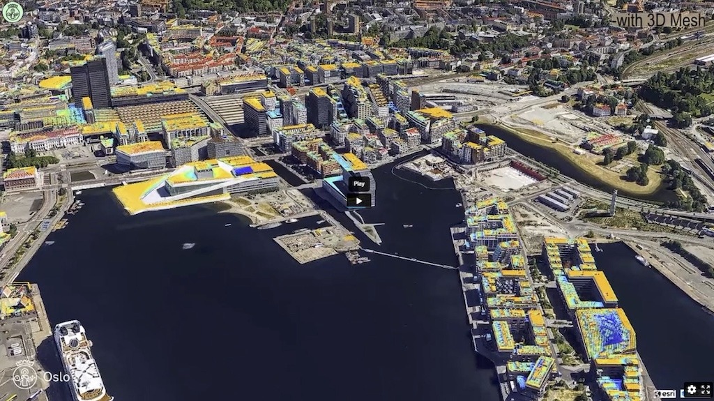
Color-coded solar radiation data was superimposed on 3D models to help identify potential locations of solar panels in conjunction with housing in the city of Oslo. Image source: City of Oslo. Click image to enlarge.
The city has also used 3D GIS to illustrate proposed developments superimposed on 3D models. For the Oslo S area, which is being developed to include various buildings and a public transport hub in downtown Oslo, city staff prepared story maps with 3D views of the development to convey various aspects of the development plans. “[The 3D views provide] a way to get it more understandable for people," said Moen. View more story maps here.
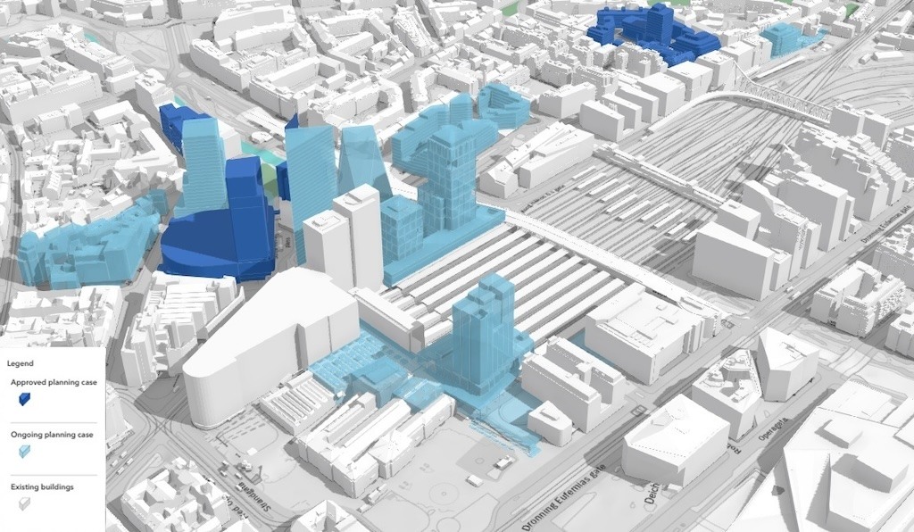
City staff prepared 3D presentations of the Oslo S area to convey development plans. Image source: City of Oslo. Click image to enlarge.
The increased used of 3D GIS in Oslo can be largely attributed to detailed LiDAR data obtained over the last couple of decades, along with more computing power, expanding staff capabilities, and greater appreciation of GIS technology by city leaders, which grew dramatically during the pandemic, according to Moen. Using Esri’s ArcGIS Online and pandemic data from Johns Hopkins University, Moen’s group was able to show current data on COVID cases, testing locations, and other related data while working remotely, heightening interest in GIS.
Moen is also seeing more interaction between different agencies, as GIS data can be used to aid planning and design of infrastructure such as drainage and utilities. “We try to help the other agencies with the data and working out problems,” he said. “They have come together with ArcGIS Online.” Moen added that control of GIS data at the city level is key to meeting the needs of a wide range of users from both the public and private sectors.
Bridging Gaps
On a global level, 3D GIS has been growing in recent years as cities and other public agencies gain access to more data and tools to display and analyze 3D data. “They're seeing the value that this extra dimension can add to GIS data,” said Taisha Fabricius, senior product manager at Esri.
The growing use of digital twins — virtual representations of physical objects or systems — is also impacting the GIS world. Already widely used among construction professionals and facility owners to design, build, and manage assets, digital twins are also becoming more common at the planning level. “Digital twins are bridging worlds,” said Fabricius. “You've got your CAD world and your GIS world and a whole bunch of other things that are coming together in digital twins.”
Fabricius cited Wellington, New Zealand, as a city actively using digital twin data for numerous applications, such as transportation management and disaster response planning. By incorporating real-time data into digital twin models, planners and the general public can access travel information on various travel modes, including automobile, bicycle, marine, and air. The city also operates an open data portal that provides public access to environmental, planning, landform, and other data.
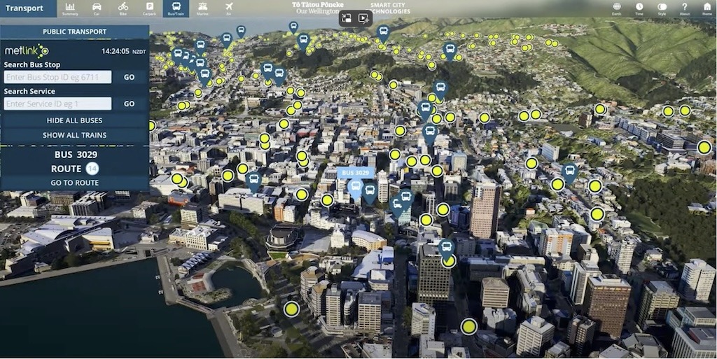
The city of Wellington, New Zealand, incorporates real-time data into digital twin models, enabling planners and the general public to access travel information on various travel modes. Image source: Buildmedia. Click image to enlarge.
Singapore has also employed large-scale digital twin technology and is “pushing the boundaries of 3D for their urban planning practices,” Fabricius said. Using technology from Bentley Systems Inc., Esri, and others, along with a combination of aerial and street-based mapping, the city produced a detailed 3D mesh of the entire city with 0.3-meter accuracy. The system is used by multiple government agencies and other parties to guide planning, design, construction, and management of facilities across the city. Read Cadalyst’s article “iLab Provides Immersive Digital Twin Experience” for more about this project.
Technology and Interoperability
Technological advancements enabling 3D GIS have emanated from CAD, BIM, GIS, and gaming software developers. An alliance partnership between Esri and Autodesk first announced in 2017 has continued to integrate BIM and GIS technologies, with products such as ArcGIS GeoBIM that combines geospatial data with design and construction information. Esri also announced earlier this year that ArcGIS Pro 3.3 supports direct-read of certain BIM elements created in Autodesk Civil 3D and Revit.
The ability to experience 3D data via virtual reality, extended reality, and augmented reality (VR/XR/AR) is also changing the GIS landscape. Esri’s ArcGIS CityEngine allows users to create interactive, immersive urban environments based on real-world GIS data or fictional designs and display multiple design alternatives in the context of expansive surroundings.
As a procedural modeling tool, CityEngine enables users to script large-scale 3D city scenes, tapping into satellite imagery, 3D meshes, and other large datasets to design in both real and fictional settings. When considering impacts of projects, “the more immersively you can experience that data, the more real that impact becomes,” said Fabricius.

This fictional design scene in Boston was developed using Esri’s CityEngine integrated with Twinmotion and Unreal Engine. Image source: Esri. Click image to enlarge.
Efforts to establish more interoperability between data formats have also helped bridge the gap between CAD and GIS. The CityGML standard developed by the Open Geospatial Consortium provides format definitions for the exchange of virtual 3D city models. The latest version, CityGML 3.0, can be implemented in a variety of technologies, including Geography Markup Language (GML) and others. It covers such areas as urban and landscape planning, BIM, mobile telecommunication, transportation, facility management, and energy and environmental simulations.
Ongoing focus on interoperability is key to enabling more collaboration among different work disciplines, according to Fabricius. “If we have more uniform data standards, then interoperability is going to be an easier piece of the puzzle,” she said.
Looking ahead, Fabricius sees GIS workflows evolving further with technologies such as artificial intelligence and machine learning. One possible scenario is enabling end users to use natural language to describe a desired outcome and relying on software tools to develop models and imagery. “It could help to actually bring what's in your head onto the screen,” she said.
As early cartographers found, accurate depictions of the Earth are not easily done on a flat plane. The challenges are compounded as larger areas of view are considered. With the aid of current technology, modern-day GIS professionals and consumers of GIS data are no longer limited to 2D products and are experiencing firsthand the benefits of working in 3D.
For more, see these resources:
Oslo Solar Radiation video, City of Oslo.
Zoning to Mesh, City of Oslo.
***
If you have GIS-based ideas or projects you think are newsworthy, drop us a line at editors@cadalyst.com.


Share This Post