The concept of digital twins — virtual replicas of physical assets — has been used for years in manufacturing and other industries to monitor the operation and maintenance of production plants and other facilities. The AEC industry has also increasingly employed digital twins to build detailed, data-rich, 3D models that help owners manage buildings and infrastructure facilities.
More recently, environmental and geospatial professionals have been using the digital twin concept to model the “un-built” world — focusing on natural resources such as soil, vegetation, water, and other assets. While the concept is not completely new to the GIS world, recent technological advancements and growing ecological awareness have helped the term “environmental twins” gain attention as a key approach to addressing a host of environmental and climate-related challenges.
Reclamation Projects
A Colorado firm has found the environmental twin concept instrumental in performing land reclamation and other services. Huwa Enterprises, which has provided reclamation and restoration services since 1985, is increasingly applying digital technology on its projects to gain efficiency and accuracy.
Working with technology provider Teren, Inc., Huwa uses LiDAR and other imagery to model vegetation, hydrology, and other assets for projects such as pipelines, renewable energy facilities, and restoration of areas impacted by wildfires and other natural disasters. Using data and analytics provided by Teren, Huwa develops mitigation and reclamation plans, performs field services, and monitors performance after installation. The digital technology has provided numerous benefits, according to CEO Brent Huwa.
“The benefits are multifaceted,” said Huwa. “We get consistency — factual, unbiased data — [from digital data]. We take out the margin of error when compared with boots on the ground and people’s opinions. We reduce our carbon footprint by not putting vehicles on the road. There’s also a safety advantage [by reducing the number of vehicles on the road and workers in the field].”
On a recent energy pipeline project, Huwa used Teren’s analytics to assess surface hydrology and identify potential hazards due to stormwater and erosion. Based on the analytics, Huwa developed measures to mitigate potential damage to the pipeline. After installation, they can monitor the effectiveness of the measures using field data collected on an ongoing basis — an environmental twin approach somewhat analogous to a manufacturing plant manager using a digital twin to monitor performance of mechanical equipment.
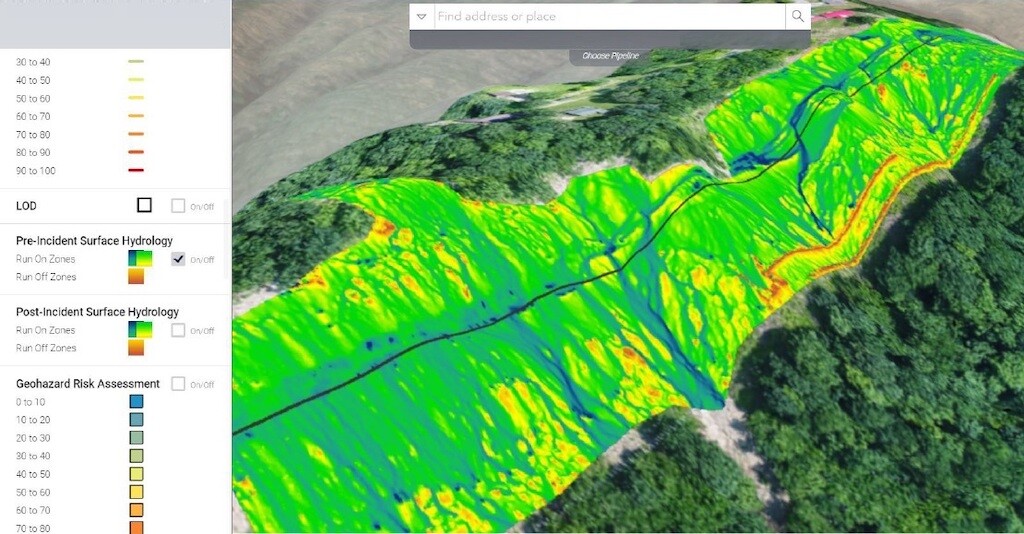
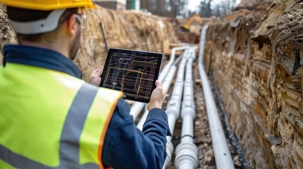
Huwa used aerial analytics and an environmental twin approach on a recent pipeline project to assess hydrology and potential hazards due to stormwater and erosion. Image source: Huwa. Click image to enlarge.
Huwa has also used similar techniques to conduct vegetation assessments to determine the overall health of vegetation in designated land areas. By assessing vegetation types and heights, they can develop measures to combat erosion and stormwater risks and protect healthy topsoil, as well as guide reclamation actions. The firm has also used digital technology to assist with wildfire assessments, identifying fire severity and developing post-fire mitigation plans.

A vegetation height assessment based on aerial analytics can help determine the overall health of vegetation in a defined portion of land. Green areas indicate taller vegetation; red area areas indicate shorter vegetation. Image source: Huwa.
A Life of Its Own
Teren co-founder and CEO Tobias Kraft said the environmental twin approach has gained traction as data collection and other technologies have improved, and customer demand for real-time data has grown. “The environmental twin thesis has taken on a life form of its own,” said Kraft. “Customers started asking us to scale what we were doing to cover larger geographies and provide data faster.”
Teran developed a cloud-based platform called Terevue that helps users anticipate, prioritize, and alert stakeholders in real time about evolving weather and environmental hazards. The company offers Terevue as a product for end-users and also provides services to clients such as Huwa, who rely on Teren to perform modeling and analytics.
Terevue is built around an ingest engine that collects and processes “vast amounts of LiDAR data and remotely-sensed imagery and fuses that with other data sources,” said Kraft. “We construct the environment around our customers' assets in 3D and incorporate that with real-time weather feeds, climate information, and so on to see how the environment is changing through time and how that's interacting with our customers’ assets.”
Teren also played a key role in a watershed management project following a major wildfire in New Mexico. The Calf Canyon/Hermits Peak Wildfire, which consumed over 341,000 acres of land in 2022, made the area highly susceptible to sediment erosion, debris flows, and flash floods. Partnering with the Natural Resources Conservation Service (NRCS), Teren performed analytics that helped ground crews target restoration efforts in critical areas.
Using a two-phase methodology, Teren first provided analysis of publicly available datasets, such as burn severity and land cover, to triage potential hazard areas. The team then used LiDAR and infrared imagery to pinpoint post-wildfire hazards, model hazard connectivity and potential impacts, delineate and prioritize reclamation treatment zones, and quantify the efficacy of treatment zone selections. The team generated triage assessments and maps within a nine-week period after disaster declaration, a fraction of the time required with traditional methods relying on topographic maps, field surveys, and damage estimate modeling, according to Teren.
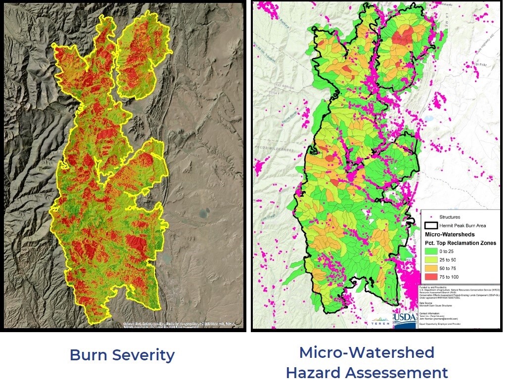
After a wildfire in New Mexico, Teren provided analysis on burn severity and other data to triage potential hazard areas. The analysis was part of a two-phase approach that also delineated and prioritized reclamation treatment zones. Image source: Teren. Click image to enlarge.
Building on Established Technology
In another example of environmental twins, the city of Raleigh, NC, is combining established GIS technology with modern data collection methods to model the effects of urban development on climate parameters. Working with the National Oceanic and Atmospheric Administration (NOAA) and MITRE, a non-profit federally funded contractor, the city combined data from heat sensors with existing GIS data to create a surface temperature model of the city. The model helped identify heat islands—urbanized areas that experience higher temperatures than outlying areas.
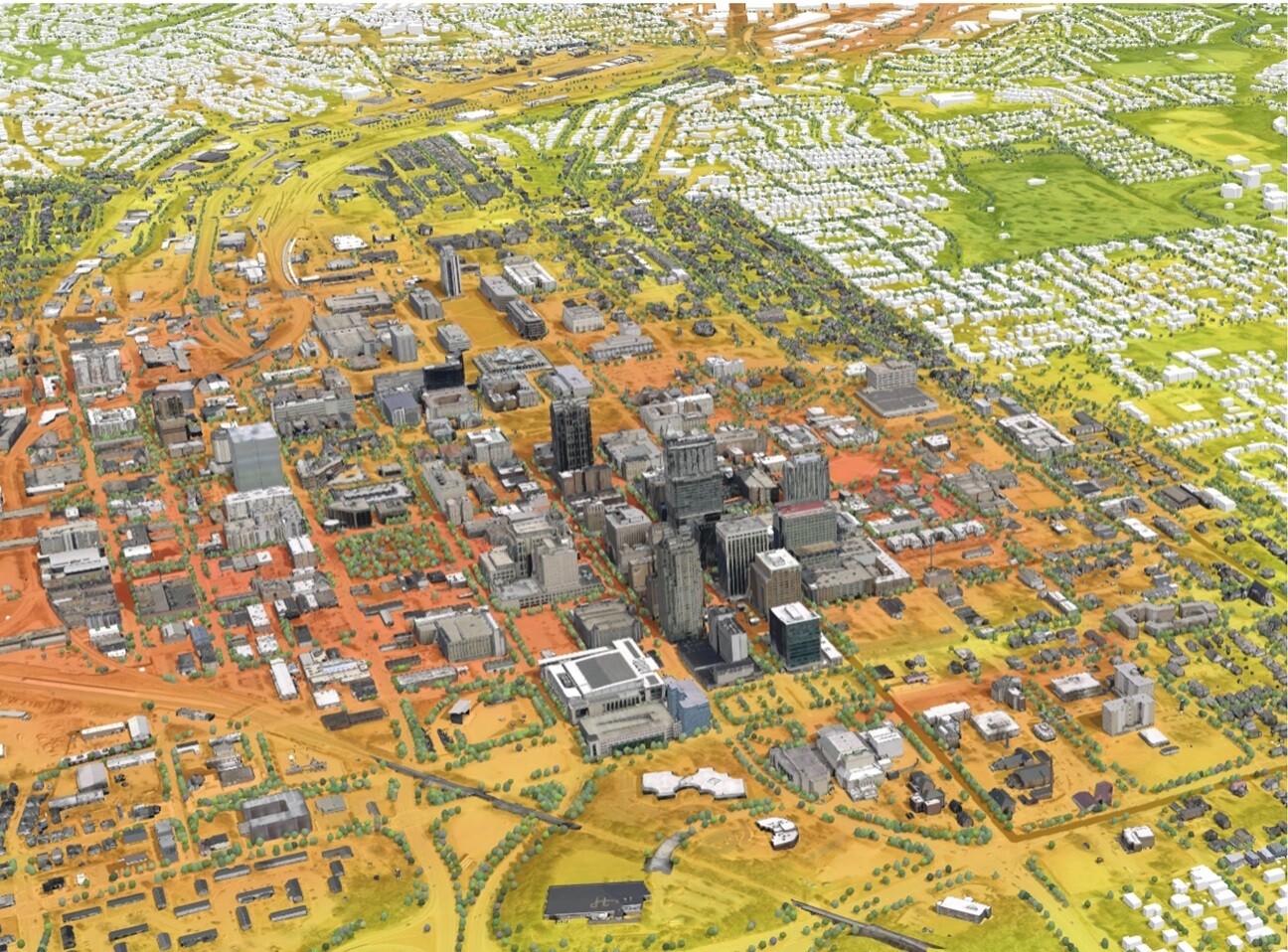
The city of Raleigh, NC, created a surface temperature model to identify heat islands. Red and orange areas are hotter than green and yellow areas. Image source: City of Raleigh. Click image to enlarge.
The temperature model is employing a digital twin approach to provide both visualization and analytical tools, according to Jim Alberque, GIS and emerging technology manager with the city of Raleigh. “We’re dipping our toe in it,” he said. “This is how we’ll be understanding what the city will look like in five years — whether it be environmental, operational, or strategic [perspectives],” he said. The city primarily uses ArcGIS Online as its publishing platform and ArcGIS Urban for digital twin and analytical capabilities.
In the near term, the temperature model is helping guide the city’s Cool Roadways Pilot Project, a program designed to reduce the amount of heat absorbed by paved roadways. The city is applying a specialized coating to help roadways reflect heat and absorb certain air pollutants. The temperature model helps prioritize which streets to include in the program, noted Alberque.
The city also used heat island data to guide the city’s Street Tree Equity Project. The visualization and analytics helped the city plan and target specific areas that would most benefit from additional trees.
Building on Established Technology
While the environmental twin approach has been used in GIS applications for many years, the term has become more common in the last year or two, perhaps due to growth of digital twins in the AEC industry. Some GIS professionals combine the terms and refer to “environmental digital twins.”
“The term ‘environmental digital twin’ is a really nice concise term for something that we've been talking about for 50 years,” said Sunny Fleming, director of environment, conservation, and natural resources solutions at Esri. “Technology is at a place now where it can be fully realized. We have this huge, robust network of real time data that is being streamed into systems and you can capture that information and bring it in to your environmental digital twin.”
Fleming sees environmental digital twins playing a key role in guiding future infrastructure improvements, such as work funded by the Infrastructure Investment and Jobs Act. “The challenge that the infrastructure bill puts in front of us is. . . can we do that work in a sustainable, resilient, and equitable way. . . and build objects through the lens of a broader perspective on the environment?” she said.
Fleming also sees opportunities for environmental digital twins to aid environmental reviews for construction projects, incorporating more visualizations into typically text-heavy processes, and to aid future construction and monitoring of solar energy panels. “Not only can we look at site suitability, but we can think about it through that economic lens, that environmental lens as well as that social lens. Can we build solar panels at such an angle on a particular slope that nobody sees it and we get X amount of wattage?”
Regardless of terminology, the environmental twin concept appears to be shaping how public and private agencies perform planning, design, construction, and monitoring — at levels ranging from individual projects to regional planning efforts. Concepts of “smart cities” and “smart agriculture” employ similar techniques in incorporating burgeoning amounts of data into urban and rural planning efforts. As technology continues to advance and data availability expands, environmental twins will likely play even greater roles in monitoring and management of our environment at micro and macro levels.


Searching for more information about Architecture, Infrastructure, and Construction?
Click here!