When the city of Cheney, Washington, wanted to know where emergency medical calls were concentrated in the city, senior planner Brett Lucas was able to provide a response with just a few mouse clicks. Using a spreadsheet with addresses of emergency medical technician (EMT) calls, he imported the data into Maptitude GIS software and generated heat maps, showing concentration of calls at various times during the year.
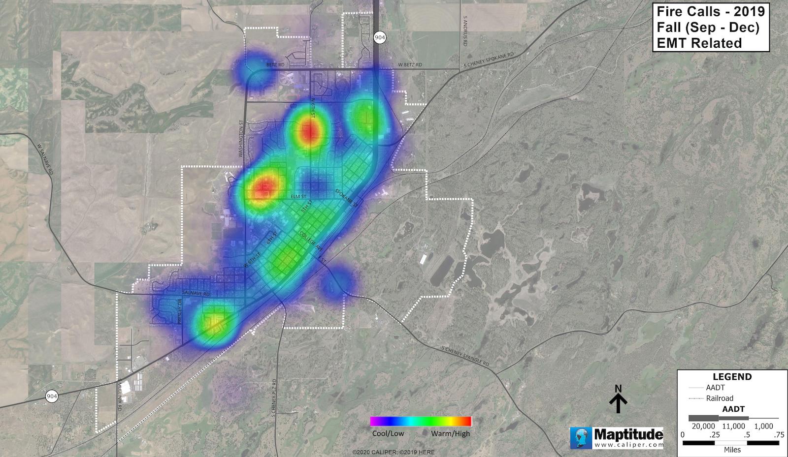
Heat maps show concentration of EMT calls in Cheney, Washington. Image source: City of Cheney. Click to enlarge image.
The maps showed two areas with high concentrations of calls during most of the year — Eastern Washington University and a nursing care facility. In the summer, the number of calls near the university dropped significantly when school was not in session. The maps proved helpful for planning purposes, as the city operates a combination career/volunteer fire department that provides emergency medical services to more than 12,000 residents, responding to nearly 1,500 calls annually from one station.
The EMT maps represent just one of numerous maps the city has generated with Maptitude, from Newton, Massachusetts-based Caliper Corporation. The software has proven a nimble, yet dependable tool for Lucas and colleagues. “You can really do things fast,” said Lucas. “Everything is drop-down menu-driven. If I need to crank out maps for a city council meeting, I can do it on short notice.”
In another example, the city performed an analysis of development patterns related to bus stops. With the Washington state legislature considering laws requiring high-density developments within certain distances of bus stops, the city manager’s office wanted to know how that might impact the city. Lucas obtained bus stop information from the regional transit agency, brought the data into Maptitude, and drew circles of varying radii around bus stops to show the areas potentially impacted.
Lucas and other city staff have also prepared maps of Cheney’s water, sewer, and electric utility lines, all of which are city owned. Using Maptitude, they have generated graduated-symbol maps that show pipes in different line weights based on pipe sizes. The team created sewer line maps by mapping manhole locations, adding pipe attributes based on as-built drawings, and connecting the dots to show information such as pipe size and flow direction.
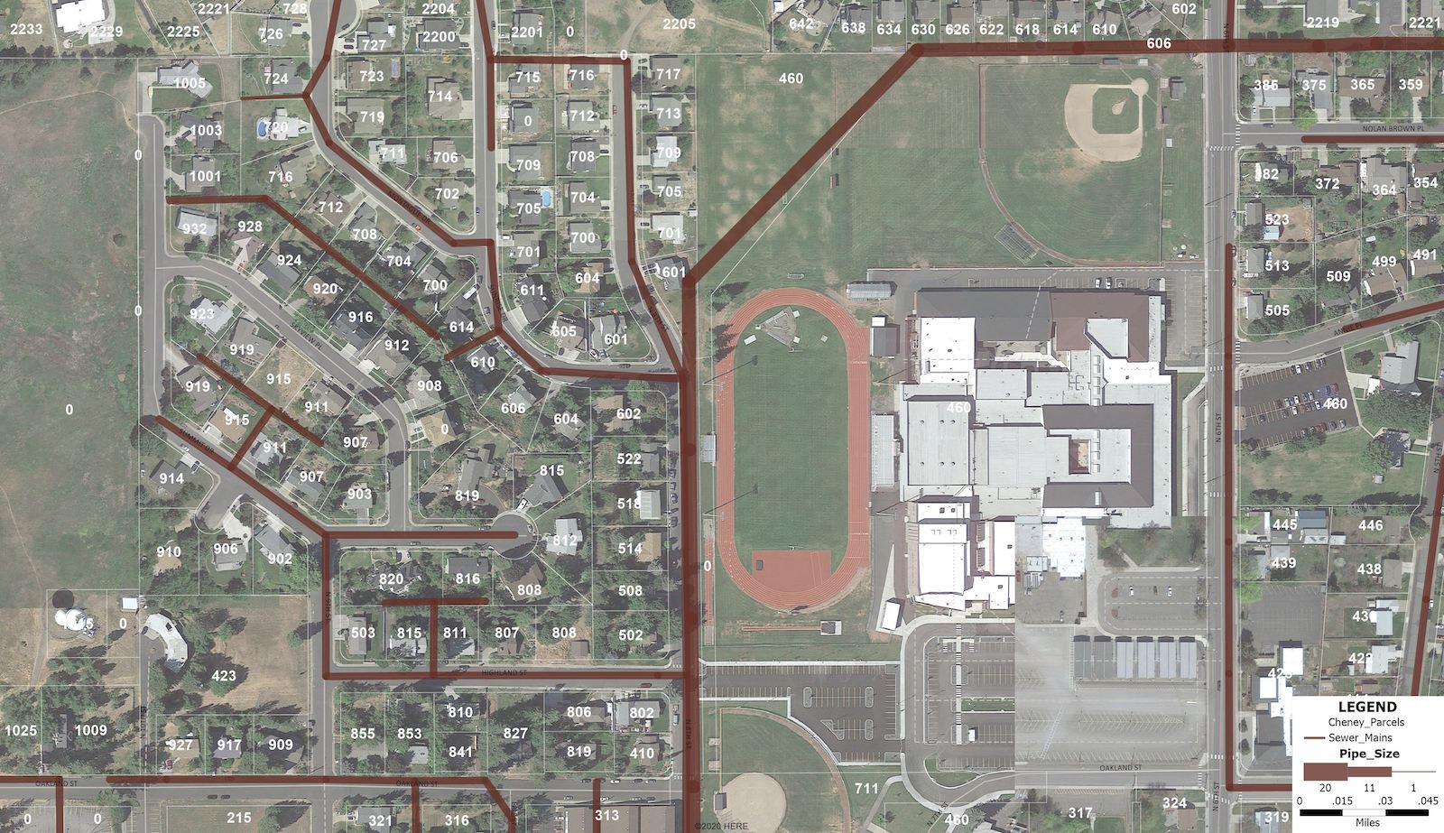
Graduated symbol maps show sewer line pipe sizes. Image source: City of Cheney. Click to enlarge image.
As a side business, Lucas also provides GIS consulting services across the U.S., focusing on retail geography, store site analysis, and economic analysis for various clients. He relies heavily on Maptitude in this practice as well, for its affordability, versatility, and ability to import data in various formats, such as DXF, DWG, and KML. “The file conversion capabilities alone are worth the price of admission,” said Lucas.
Guiding Schools
Consultants have also used Maptitude in various other applications, such as determining education and political boundaries. Preston Smith, principal owner of Kansas City-based Business Information Services, LLC, uses Maptitude to help school districts manage enrollments and attendance boundary issues. On a recent project in Oklahoma City, BIS was hired to analyze enrollment patterns and determine which schools to close. The firm generated numerous maps, such as one showing where people had moved into and out of the school district during the previous year.
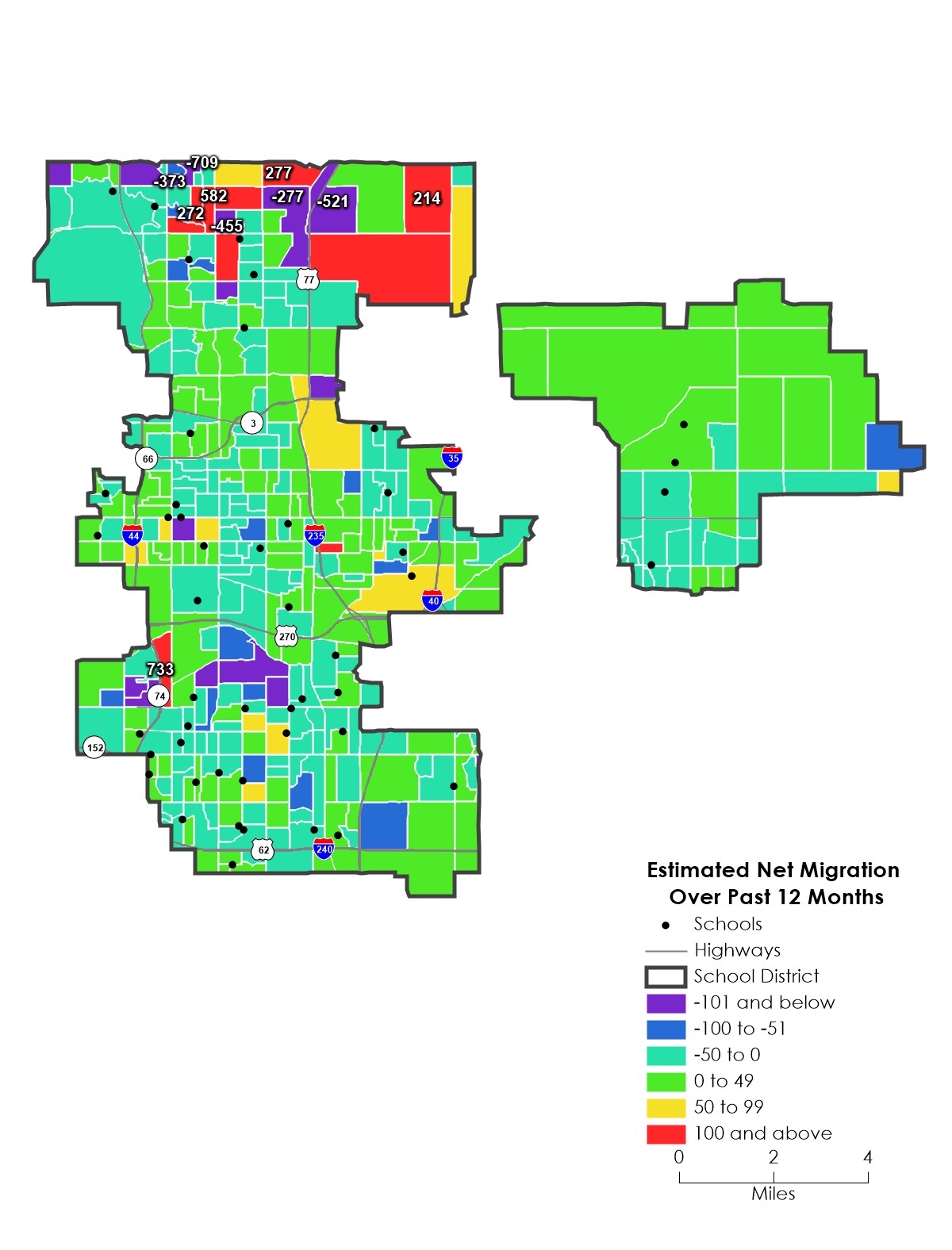
Map shows migration of students in Oklahoma City. Image source: Business Information Services, LLC. Click to enlarge image.
With 89 schools in the district, Oklahoma City Public Schools (OKCPS) was seeking to improve efficiency and close schools where populations were decreasing. Using Caliper’s Maptitude for Redistricting tool, BIS was able to recalculate new student counts for each school on-the-fly with multiple school district administrators. “We considered many factors to determine which school to close, and this provided one more data point,” said Smith.
Smith’s team also used Maptitude to generate geocodes matching student addresses with latitude/longitude location information and show graphically which schools students attend. “Without Maptitude, we could not have even considered what a 40,000-enrollment school district would look like,” said Smith. “We were able to quickly and accurately count students by grade and even know what school in each area the students attended. This sped up the decision-making process to only a few days, in an online session, versus what could have been months or longer.”
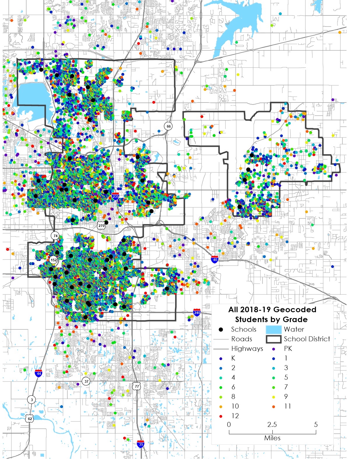
Maptitude generated geocodes of students in relation to schools. Image source: Business Information Services, LLC. Click to enlarge image.
BIS has also used Maptitude on other school district studies across the U.S. A typical school demographic study might generate up to 80 maps, along with numerous tables and graphs, including data for the last 25 years for enrollment, building permits, and economic data, plus enrollment projections for the next 10 years using various statistical models.
Maptitude Evolves
First released in 1995, Maptitude mapping software was conceived as part of Caliper’s consulting practice. The software formed the core GIS in Caliper’s suite of transportation products and enabled the firm to address various business applications, according to Stewart Berry, vice president of product management. Maptitude was the basis for the Community 2020 community planning software, produced by Caliper in the 1990s for the U.S. Department of Housing and Urban Development (HUD), and evolved into a commercial mapping software product that provides visualization, geographic analysis, and many other data processing tools. Maptitude comes with a comprehensive library of nationwide and worldwide maps and census demographics.
Maptitude has also played a key role in U.S. Census efforts. To support the 2010 Census, the U.S. Census Bureau implemented a Maptitude-based solution, named MAF/TIGER Partnership Software (MTPS). The solution combined census address lists (Master Address File or “MAF”) and nationwide digital maps (the “TIGER” map) in a single software package to establish decennial Census data, according to Berry. Maptitude for Redistricting, a version of Maptitude designed for dividing areas into population-based districts, is used by almost all state legislatures, multiple political parties, and public interest groups, he said.
In addition to Maptitude for Redistricting, Caliper offers Maptitude for Precinct and Election Management (Maptitude P&E), a product geared to create precinct and election management solutions. It can be used stand-alone or in conjunction with county and statewide voter registration software to compute the number of registered voters in individual precincts, along with other related data.
Caliper also developed TransCAD for transportation planning and TransModeler for traffic simulation. TransCAD is used in both the public and private sectors for transportation database development and maintenance, demand forecasting, operations management, and vehicle routing and scheduling. TransModeler performs various traffic modeling and simulation tasks, such as road and multimodal network analyses. The two products can also be used together to perform operational analyses of transportation projects and plans.
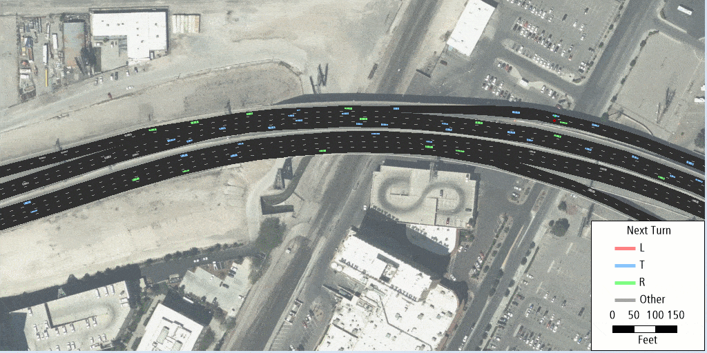
TransModeler can be used to perform turning movement analyses and other traffic simulations. Image source: Caliper Corp. Click for animated GIF.
Moving to the Cloud
With software generally trending toward cloud-based platforms, Maptitude is also moving in that direction, according to Berry. The company recently released Maptitude Online, which is both a map sharing add-in for desktop Maptitude and a stand-alone mapping application. “In the future, more customers will be shifting to cloud,” said Berry. “The biggest demand we see is people wanting to share their maps.”
Maptitude users see similar trends in GIS. “The future is definitely going to be more web-based,” said Smith. “Instead of hardcopies, people want live updates.”
Lucas agrees, but sees pros and cons with some of the trends. “I see more cloud work and less work in desktop packages,” he said. “It has its merits when working remotely. The sad part is paper maps will be harder to find.” A self-professed mapping enthusiast, Lucas often combines vacations with exploring obscure parts of the U.S., such as small Midwestern towns, regularly using paper maps to navigate in remote areas.
Other mapping professionals likely share Lucas’ nostalgic appreciation of traditional maps. But with the wealth of information available at the click of a mouse, the many advantages of modern GIS solutions such as Maptitude are hard to dispute.


Searching for more information about Architecture, Infrastructure, and Construction?
Click here!