As drones have become more publicly accessible over the last couple of decades, construction contractors have found numerous uses for them. Firms have used drones, a.k.a. unmanned aerial vehicles (UAVs), to plan projects, track progress, identify potential safety issues, create basic project site maps, and perform various other tasks.
In a more recent twist, construction firms are integrating GIS and drone technology to produce more precise, real-world data that can assist workers in real time. With this combination, firms can accomplish more complex tasks, such as monitoring underground utilities, determining earthwork quantities, and linking real-time construction data with CAD models and digital twins.
Big Benefits Underground
General contractor Brasfield & Gorrie has realized big benefits from the GIS-drone integration. The firm, one of the largest privately held construction companies in the US, has been using drone mapping and CAD data for several years to monitor new and existing utilities, and it has found even greater gains when introducing GIS into the picture.
“We started out just doing the mapping [with drones],” explained Ryan Hittie, senior innovation and operational technology specialist at Brasfield & Gorrie. “The technology evolved... and we got more functionality,” he said, noting how field engineers started overlaying CAD data on drone maps to aid utility location.
While the CAD overlays were helpful in locating underground utilities, the process relied primarily on snapshots of drone mapping overlaid with CAD data posted on a “dig board” near each project’s construction trailer. “Team members would still have to walk to the trailer, find where they're going on the map, remember where they're going, or take a picture of it,” noted Hittie.

Brasfield & Gorrie has overlaid CAD data on drone mapping to help identify underground utilities. Image source: Brasfield & Gorrie.
To bring a more real-time approach to the process, Brasfield & Gorrie introduced GIS technology and merged drone mapping, GIS, CAD, and other data, enabling users to orient themselves on job sites using GPS-enabled devices such as mobile phones. With data integrated in Esri’s ArcGIS Online, field personnel can simply scan a QR code with a mobile device and view up-to-date mapping. “This enables the field team to understand in real time their location on the job site in relation to what's underground,” said Kyle Duncan, an innovation and operational technology specialist at Brasfield & Gorrie.
Since implementing this technology, Brasfield & Gorrie has seen a decrease in utility strikes — unintentional contact of buried utility lines. The firm has also used drone data to identify open trenches for new utilities and produce timelines identifying when utilities were installed. “Now we actually have a visual, not only the CAD file, but we can actually tell when and where it was installed,” said Duncan. “We can fly the drone daily or at every milestone, every time the ground is open,” he added.

Drones can be used to provide project updates in real time. Image source: Brasfield & Gorrie.
More Accessible Technology
The marriage of drones and GIS in construction and other fields can be traced to growing accessibility of GPS-equipped drones, as well as more accurate global navigation satellite system (GNSS) data. In 2000, the U.S. government ended its use of selective availability, which intentionally degraded civilian accuracy of GPS/GNSS data. “Prior to that, collecting GPS data was done with very technical people” using sophisticated equipment and software, noted Andrew Carey, senior global account executive (AEC) at Esri. The removal of that accuracy degradation “meant that a person could go buy a piece of GPS equipment and go start collecting data and attributing that data. When that happened, it really exploded the use of GIS,” said Carey.
The integrated technology has been attractive to engineers and construction contractors because they “can start sharing and building all these things from it and comparing it to other things in a database,” said Carey. “They want the data in other places than just the survey department.”
Since 2018, Brasfield & Gorrie has expanded its use of drones from six to nearly 40 units, with up to 20 more scheduled to come on line in 2024. Approximately 50 employees are trained as pilots, which requires certification with the Federal Aviation Administration (FAA). Based on a recent ArcGIS report, the company's GIS data has been accessed through ArcGIS Online by more than 4,000 users, including trade contractors who incorporate the information into their processes and clients who check in on a project's progress.
As the company has gained experience with GIS-drone integration, Brasfield & Gorrie has also been venturing further into the world of digital twins. “A couple of years ago, everyone just thought of the coordinated architectural model and the digital version of the building [as the digital twin],” said Hittie. But now we've evolved to where you can take 2D or 3D data, put it on top of your 3D model and then have an ‘evolved’ digital twin. We have multiple layers and all dimensions — models, maps, markups, inspections, 360-degree camera data, point clouds, GNSS points, or linework. Any data that we capture, goes into that.”
In another application, the company recently used drone-based technology to verify a disputed gravel quantity. With the disputed amount worth approximately $50,000, teams used drone data to build a 3D mesh of the site and accurately quantify the amount, effectively settling the dispute.
The company is also exploring how to use drone data in autonomous grade control. “We can take a greenfield site, even if it has trees on it, and get a topo map through trees before we even touch the ground with a dozer,” said Hittie. "We can figure out how much dirt is out there, what the topography of the land looks like, and plan ahead. We can get a volumetric report of how much dirt needs to be removed.” Using GPS-equipped excavation equipment, teams can perform grading based on a 3D design model. “That's a new source of savings for us, instead of having to go out, stake it, measure it repeatedly,” he added.
Real-world Orientation
As AEC firms find ways to integrate GIS and drone technology, Esri’s Carey sees more opportunities to tie projects into real-world coordinate systems, rather than use localized coordinates. Even with growing accessibility to established survey and mapping data, many projects are still designed and built based on localized coordinate systems, where a 0,0 origin is arbitrarily assumed at a convenient location. Project participants may see this as a way to avoid additional time and expense of tying a project into State Plane or other geographically oriented coordinate systems. In reality, real-world orientation opens doors to higher-quality, more effective projects.
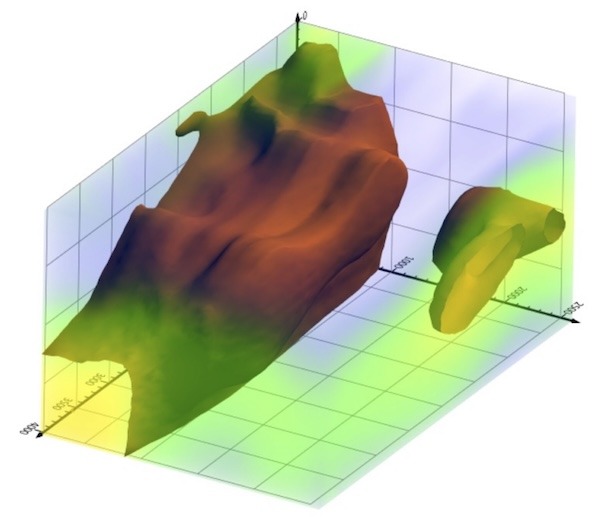
“When engineering firms use real world coordinates in their BIM models, it enhances what they can do with them,” said Carey. As an example, he cited a port in Taiwan that is being fortified for potential rising sea levels. Using drone-acquired point cloud mapping, planners could apply various sea level rises to visualize how the port would be impacted. “It's a digital model that we can apply things to and visualize what happens,” he said.


Drone-acquired point cloud mapping was used to model various sea level rises would impact port facilities. Image source: Esri.
Accuracy Tools
The growing accessibility of GIS and drone data has also generated discussion about data accuracy. While the accuracy of publicly available mapping has been improving in recent years, the increased accessibility also means data accuracy may not be fully understood by end users. “We've taken a piece of technology and made it very accessible to people that don't have survey backgrounds, and they're producing products that they can't necessarily stand behind,” said Carey.
To help address the issue, the American Society for Photogrammetry and Remote Sensing (ASPRS) has been reviewing industry standards and in August released updated standards on positional accuracy for geospatial data. The updated standards include guidelines for field surveying of ground control and checkpoints and address evolving technologies. Esri also released an accuracy assessment tool in conjunction with ASPRS that helps independently validate the accuracy of image products.
The integration of GIS and drone technologies clearly offers new opportunities for AEC and GIS professionals. As with any new technology, firms may encounter hurdles in implementing the tools, but the possibilities are intriguing. The availability of more real-time data can help numerous projects get designed and built more smoothly and efficiently.


Share This Post