In its early days, GIS was buoyed largely by planning-level data, providing far less precision than that found in project-specific engineering surveys and plans. GIS data encompassing cities and large facilities sufficed for analyzing natural resources, demographics, infrastructure systems, and other large-scale assets, but generally did not contain the detail needed to zoom in on specific elements such as buildings and specific utility components.
Technology is changing some of these long-held assumptions and enabling crossover amongst GIS, CAD, and BIM workflows. Combining a burgeoning amount of data available from drones, satellites, and land-based surveys, GIS professionals can now create photorealistic, 3D models of cities and other expansive areas and use the models for detailed analysis.
A new software suite from Esri appears closely aligned with these trends, offering tools to manage large amounts of data with increasing levels of accuracy. Esri’s ArcGIS Reality is geared for site, city, and regional mapping, enabling users to create digital twins of large areas much like AEC professionals have been doing on specific building projects or facilities.
“The line between GIS and CAD has been blurred over the years,” said Kurt Schwoppe, Esri’s business development manager for imagery. “We are very mindful of that and want to have products that play equally well in both of those arenas.”
Based on a new ArcGIS Reality engine, the new suite can be used as an extension of Esri’s flagship product, ArcGIS Pro, or on a standalone basis as ArcGIS Reality Studio. The tools largely evolved from technology developed by nFrames, a German company acquired by Esri in 2020. The nFrames software was capable of processing large volumes of aerial imagery at a 2- to 4-cm resolution, but lacked back-end photogrammetry tools to produce more accurate, photorealistic 3D models, according to Schwoppe.
After adding more robust photogrammetry capabilities to the nFrames technology, Esri released the ArcGiS Reality suite in February. The product family can now work with imagery from a wide range of sources, including high-end aerial mapping equipment, drones, and other sources, to produce photorealistic 3D visualizations as foundational data for digital twins, noted Schwoppe. Models can also import CAD and BIM data using indexed 3D scene layers (I3S) technology, which aids the encoding and transmission of various geospatial data types.
High-resolution Modeling
As a demonstration of the new technology, Esri partner Bluesky International Ltd., built a 3D model of Boston with 4-cm resolution. The team used an aerial mapping system consisting of five cameras plus LIDAR data collection. Ground survey control points were added to improve accuracy. Artificial intelligence built into ArgGIS Reality was used to weed out moving objects such as automobiles.
With a high-definition 3D mesh of visible features, the Boston model and others like it can be used to perform 3D measurements and other analyses. Features such as building faces and building corners have X, Y, Z coordinates that can be tied to a specific survey datum, enabling users to locate model features in relation to other known data points.
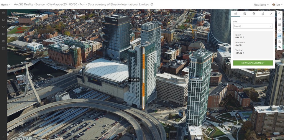
Photorealistic 3D models such as this model of Boston can be used to perform 3D measurements and other analyses. Image source: Bluesky International, Ltd. Click image to enlarge.
Users can also apply GIS data to model features and access GIS attributes, such as property ownership, historical data, and other information. “It’s more than just a visualization,” noted Schwoppe. “It’s a way to do analysis.”
The ArcGIS Reality suite also includes Site Scan for ArcGIS, a cloud-based reality mapping tool for smaller datasets, and ArcGIS Drone2Map, a desktop application focused on reality mapping from drone imagery. Site Scan, originally released by 3DR in 2016 and acquired by Esri in 2019, is designed to simplify drone program management, imagery data collection, processing, and analysis. Drone2Map, released in 2016, enables offline processing and rapid mapping in the field. Another product, ArcGIS GeoBIM, while not part of the suite, interconnects ArcGIS with Autodesk Construction Cloud products and enables teams to integrate and visualize project data in a single, cloud-to-cloud solution (see previous Cadalyst article).
The new ArcGIS Reality tools are intended to meet a growing demand for captured reality to serve as the foundation for digital twins and other infrastructure models, according to Marc Goldman, Esri’s director of industry solutions for AEC professions. The reality capture concept enables users to access photorealistic models that can be updated as needed via aerial imagery and other sources to monitor assets, track construction activities, and perform predictive simulations. “It’s becoming an expectation of the way we plan, design, build, and operate things,” said Goldman.
Industry data also corroborates rapid growth in aerial imagery. A Fortune Business Insights report projected the aerial imaging market to grow from $1.4 billion in 2017 to over $4 billion by 2025.
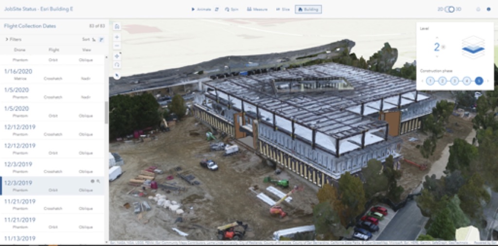
ArcGIS Reality can be used to monitor construction projects and other assets using regularly updated imagery from multiple sources. Image source: Esri. Click image to enlarge.
New Possibilities for Industry Practitioners
For private firms and public agencies performing GIS work, the Esri suite provides additional tools to tackle large volumes of imagery from multiple sources. “It opens doors to bring in a significantly larger number of images,” said Bobby Valentine, technologist for visualization and reality capture at consultant Kimley Horn. “It also opens doors for different sensor technology.”
Kimley Horn conducts aerial mapping with a multispectral, five-sensor camera, and also has access to a hyperspectral, 10-sensor camera. With a single image often containing 8- to 10GB of data, the volume of data grows rapidly with multi-sensor cameras. The firm has been using Site Scan for eight years but has sometimes encountered limitations in the number of images that cloud-based Site Scan can handle. Based on initial testing, the desktop capabilities of ArcGIS Reality should allow the firm to process much larger volumes of imagery, according to Valentine.
ArcGIS Reality should also enable Kimley Horn to more readily incorporate terrestrial data along with aerial data in mapping. The firm uses multiple mapping tools from other vendors, depending on project and client needs. “Adding something like this takes it to the next level,” said Valentine. “We can take all the information we capture and put it together in one spot.”
A variety of other tools are available for mapping aerial imagery, including Recap Pro from Autodesk, ContextCapture from Bentley Systems, Correlator3D from SimActive Inc., Agisoft Metashape from Agisoft LLC, and Pix4DMapper, from Pix4D SA. An open-source tool, WebODM, is also available for tech-savvy, budget-minded organizations willing to pay a small one-time fee and get under the hood with some coding. Capabilities of the various products vary, so applicability will depend on project needs, system capabilities, and other factors.
With evolving technology expanding the capabilities of mapping and imaging tools, the GIS landscape looks much different today than just five years ago. Tools that were once only available to specialized mapping organizations are now available to a much larger audience. Large-scale maps that were often used only for planning-level work are evolving into detailed models that provide valuable data for engineering, architecture, facilities management, and other areas. As with most technology, proper application will still require involvement of qualified professionals, but access to powerful tools is growing by leaps and bounds. Photorealistic 3D models of cities and regions will likely become even more commonplace as more industry professionals harness the technology.


Share This Post